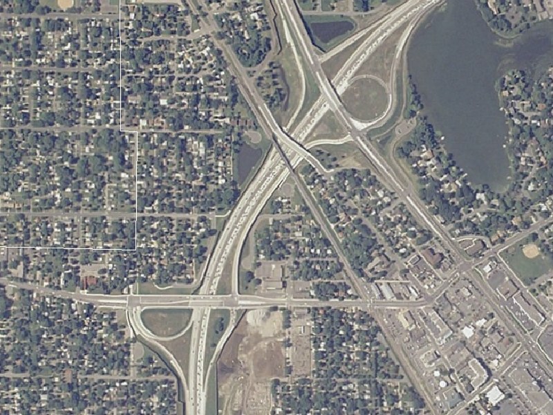
MN 100/CSAH 9/CSAH 81 Robbinsdale Aerial Image
These images are courtesy of the National Agriculture Imagery Program, a program of the U.S. Department of Agriculture, and were taken in 2005.
This view, at 6-feet-per-pixel resolution, shows the newly reconstructed MN 100/CSAH 9/CSAH 81 area in Golden Valley. MN 100 runs south-to-northeast, CSAH 9/42nd Ave N runs east-west, and CSAH 81 runs southeast-northwest.
Prior to the 2002-2004 MN 100 reconstruction project, MN 100 was a 4-lane expressway through this area, with an at-grade intersection at CSAH 81 and a 3/4 diamond at CSAH 9/42nd Ave N. The missing ramp at CSAH 9 was a southbound off-ramp...this movement was instead served by a right-in/right-out on the southbound side at 43rd Ave N.
The MN 100 reconstruction project, part of a plan to turn MN 100 into a full freeway, made several changes to the area. First off, MN 100 was widened to 6 lanes south of CSAH 81. Second, the CSAH 9 interchange was revised into a partial folded-diamond, with a southbound off-loop. Due to the proximity between CSAH 9 and CSAH 81, a northbound connector road was built between CSAH 9 and CSAH 81. The former CSAH 81 intersection was upgraded into a 3/4 interchange, with diamond ramps to/from MN 100 north, and a direct ramp and loop favoring traffic between MN 100 SOUTH and CSAH 81 NORTH. All pavement and former bridges were fully replaced.
Return to Twin Cites Aerial Images
Return to Twin Cities Highways
![]()
Page last modified 20 May, 2008