|
From:
|
|
From:
|
The guide goes from south to north, as the mileposts do, so if you are heading southbound, go to the bottom and scroll up. At freeway/freeway junctions where no control cities exist, none are listed. Italics indicate destinations/routes not marked as such. Where the background of a state or county route marker is black, the marked route is not indicated on freeway signage. Route shields framed in blue indicate Exit List continuations (click on the shield to continue).
Northbound |
Southbound |
Interchange Type or Diagram |
Notes |
 |
|
||
2 lanes each direction |
|||
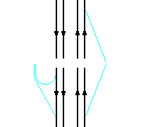
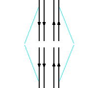
Sharp
Curve - 90 degrees |
|||
|
|||
On-ramp from Franklin Ave |
|||
On-ramp from
|
|||
3rd lane from EB-NB on-ramp to Exit 17C |
|||
Exit 16B
|
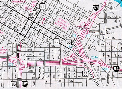
Part of Spaghetti Junction |
||
|
|||
Exit 17C
|
On-ramp from Washington Ave/3rd St C/D road |
South end of
complex interchange |
University of Minnesota EAST |
|
Metrodome WEST |
|||
|
ALL TRAFFIC MUST EXIT. |
|||
|
CLOSED!!! Northbound I-35W
CLOSED |
|
||
(CLOSED) Exit 17A
|
East
end of Spaghetti Junction |
||
| 3rd-4th lane gain from WB-NB on-ramp | 3rd-4th lane drop at Exit 17A | ||
(CLOSED) Exit 17B
|
North end of SB C/D road |
||
(CLOSED) Exit 17C
|
North end of complex interchange |
To
University of Minnesota EAST |
|
|
Metrodome WEST |
|||
Mississippi River Bridge COLLAPSED 1 August, 2007 Replacement bridge under construction, estimated completion late 2008 |
|||
|
CLOSED!!! Southbound I-35W CLOSED |
|
||
|
On-ramp from 4th St SE |
Exit 18
|
Elongated diamond |
University of Minnesota EAST |
|
One lane open
|
Lane ends at off-ramp ALL TRAFFIC MUST EXIT |
||
Exit 19
|
On-ramp CLOSED |
Half-diamond to/from SOUTH |
|
Exit 21A
|
|
South end of elongated diamond |
|
(CLOSED) Exit 21B Johnson St NE |
CLOSED!!! Southbound I-35W CLOSED between Stinson Blvd and I-94 |
Within ramps for Exit 21A |
|
Exit 21A
|
North end of elongated diamond |
||
| 2nd lane gain from on-ramp | 2nd lane drop at off-ramp | ||
Exit 21B TO
|
Exit 21B St Anthony Blvd |
||
Roseville |
Minneapolis |
Milepost 21.8 |
|
|
On-ramp from northbound
|
|
Partial-directional
interchange |
|
| 3rd-4th lane gains from on-ramp | 3rd-4th lane drops at off-ramp | ||
|
|
Partial-directional/cloverleaf |
||
| 4th-lane drop at MN 36 split | 4th lane gain from WB MN 36 on-ramp | ||
Exit 24
|
Folded-diamond to NORTH |
||
Exit 25A
|
Partial
folded-diamond |
||
Roseville/Arden Hills/New
Brighton City Line at County D |
|||
Exit 25B
|
Partial-directional |
||
Exit 26
|
|||
|
|
Cloverleaf interchange |
||
Eastbound |
Westbound |
Interchange Type or Diagram |
Notes |
 |
|
||
Exit 28A
|
|||
|
|
||
Exit 28B
|
Exit 28B
|
Partial
directional interchange |
|
| 4th lane gain from NB on-ramp | 4th lane drop at Exit 28B | ||
Arden Hills/New
Brighton/Mounds View City Line at CR 10 WEST |
|||
|
|||
Exit 28C
|
Partial
folded-diamond |
||
Exit 29
|
Folded diamond to SOUTH |
||
Arden Hills/Mounds
View/Shoreview City Line at County I |
|||
|
|
||
|
|
Trumpet
interchange |
||
| 4th lane drop at Exit 30 | 3rd-4th lane gain from SB on-ramp | ||
Mounds
View/Shoreview/Blaine City Line at US 10 WEST |
|||
|
|||
Exit 31A
|
SB on-ramp is
loop |
||
Blaine |
Shoreview |
Milepost 30.7 |
|
Exit 31B
|
Partial-directional to/from SOUTH |
||
|
3rd lane drop at Exit 31B |
|||
 |
|
||
Exit 32
|
|
||
Exit 33
|
|
||
Lino Lakes |
Blaine |
Milepost 34.8 |
|
Exit 36
|
|
||
Columbus Township |
Lino Lakes |
Milepost 40.8 |
|
2 lanes each direction |
|||
END
|
|||
|
|
||
Northbound |
Southbound |
Notes |
|
|
From:
|
Links:
![]()
Page last modified 23 March, 2008
 Exit Guide


 WEST
WEST EAST
EAST


