
Dakota County
This page covers I-494 from the MN 5 EAST interchange near the airport and Minnesota River to the US 52 interchange in Inver Grove Heights. Total length of this section is approximately 8 miles.
Description
This is the newest section of I-494, having been opened in the mid 1980s. Designed for a more recent traffic count year, this is also the least-congested section of I-494, but still sees a lot of traffic and has occasional backups across the Minnesota River. Also due to its late construction, this is the only section of the 494/694 beltline that was built to 6 lanes at initial construction, and one of only 3 sections that MnDOT deems adequate for 2020.
Roadway Configuration
6 lanes throughout
C/D road on EB I-494 at the I-35E interchange
C/D roads between MN 110 and US 52
Auxiliary lanes between interchanges between Pilot Knob Rd and MN 149
Average Daily Traffic Counts
| Location | 1982 | 1984 | 1986 | 1988 | 1990 | 1992 | 1994 |
| Minnesota River Bridge | 9,600 | 25,800 | 41,600 | 50,000 | 51,000 | 60,000 | 91,000 |
| W of I-35E | 6,600 | 11,000 | 39,000 | 45,000 | 46,000 | 54,000 | 90,000 |
| W of MN 149 | N/A | N/A | 36,900 | 49,700 | 56,000 | 59,000 | 96,000 |
| W of MN 3 | N/A | N/A | 28,300 | 41,400 | 46,000 | 49,000 | 75,000 |
| W of MN 110 | N/A | N/A | 23,400 | 34,400 | 37,500 | 40,000 | 62,000 |
| W of US 52 | N/A | 30,100 | 39,300 | 50,200 | 52,500 | 57,500 | 78,500 |
| Location | 1996 | 1998 | 2000 | 2002 | 2004 | 2006 | 10-yr '96-'06 Change |
| Minnesota River Bridge | 88,000 | 94,000 | 101,000 | 93,000 | 86,000 | 90,000 | +2% |
| W of I-35E | 80,000 | 88,000 | 97,000 | 90,000 | 86,000 | 87,000 | +9% |
| W of MN 149 | 94,000 | 91,000 | 97,000 | 94,000 | 92,000 | 93,000 | -1% |
| W of MN 3 | 86,000 | 82,000 | 86,000 | 83,000 | 87,000 | 87,000 | +1% |
| W of MN 110 | 74,000 | 71,000 | 74,000 | 72,000 | 76,000 | 76,000 | +3% |
| W of US 52 | 94,000 | 91,000 | 96,000 | 95,000 | 98,000 | 96,000 | +2% |
The Minnesota River bridge was opened between 1980 and 1982.
I-494 fully opened to traffic on November 26, 1986. 1986
counts are from after this opening.
Traffic volumes in 2004 are low due to pavement reconstruction.
Click HERE for the Exit List
Speed Limit
History
Future Plans
Froggie Suggests
Images (click on a thumbnail for a larger view)
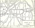 |
This 1975 map, from the Study Report on Uncompleted Interstate Segments in the Twin Cities Metropolitan Area, shows I-494 proposed along generally the same alignment it occupies today. It also shows a 1960s-era proposal for the I-35E/I-494/MN 55 interchange area. |
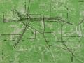 |
This ca. 1976 map, from the I-494 Draft EIS, shows the most extravagant option considered for I-494 through Dakota County, with up to 6 carriageways located between I-35E and a relocated MN 55, which at the time was proposed to become a freeway. |
Links
Last updated 12 May, 2008