
Uncompleted
I-94 to I-35W in Minneapolis
From the "Study Report on Uncompleted Interstate Segments in the Twin Cities Metropolitan Area", a study ordered by the 1975 Minnesota Legislature that directed the Metropolitan Council, the Transportation Advisory Board, and the cities involved to review the then-uncompleted segments of Interstate Highway within the 7-county metro area and make recommendations on those segments.
History of the Project
This segment of the Interstate was not a part of the original metropolitan freeway system. The Interstate corridor that had been designated established three sides of a ring around the Central Business District (CBD) of Minneapolis. I-94 on the south and west side with I-35W on the east, left a gap on the north side that was referred to as the North Ring Route. The route had been proposed by the Automotive Safety Foundation in their Major Thoroughfare Plan and also in 1957 in the report entitled Freeways in Minneapolis that had been prepared as a joint study by the Minneapolis City Council and Planning Commission and the consulting firm of George W. Barton and Associates.
On May 11, 1962, the City of Minneapolis by resolution recommended designation of the North Ring Route as a part of the Interstate highway system. In April, 1963, the Minnesota Highway Department (MHD) made the request to the Federal Highway Administration (FHWA, at that time the Bureau of Public Roads) to add the segment to the Interstate system.
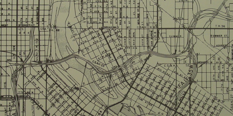
On December 21, 1964, a Corridor Public Hearing was held in the Minneapolis City Hall, at which the freeway was explained. [Webmaster's Note: this map shows the proposal at the time.]
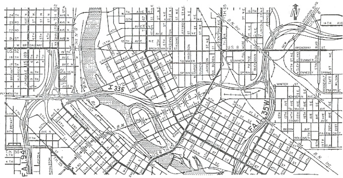
In October, 1967, a major change in the alignment was made in the vicinity of the easterly side of the Mississippi River crossing. The plan shifted the alignment northerly from Nicollet Island and to the B.F. Nelson Roofing property. The freeway proposal was also revised from an elevated to a depressed section between Main St NE and 4th St NE at this time. [Webmaster's Note: this map shows the revised proposal.]
On August 5, 1970, a Design Public Hearing was held to present the latest plan. The City had approved the plan on July 31, 1970 by resolution. However, the Mayor vetoed the resolution August 10, 1970. Subsequently, the City Council overruled the veto at their August 25, 1970 council meeting and approved the plan.
In 1971 and 1972, there were several citizens groups formed that opposed the freeway and objected to the elevated segment of the freeway easterly of 4th St NE.
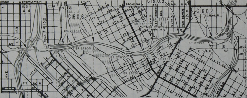
In April, 1972, MHD completed a revised plan that depressed the freeway easterly of 4th St NE. This plan was approved by the FHWA. Subsequently, on June 9, 1972, the Minneapolis City Council rescinded all plan approvals for I-335. [Webmaster's Note: this map shows the changes MHD made in an attempt to save the project.]
In January, 1973, a consultant, Hodne-Stageberg Partners, Inc. was engaged to make an EIS and investigate all aspects of the problem, including the no-build alternative. They recommended reanalysis of the traffic projections and additional noise studies. The traffic studies have just been completed and the Hodne-Stageberg Partners, Inc. contract has been terminated.
On July 25, 1975, the Minneapolis City Council passed a resolution opposing construction of I-335 and the equivalent money programmed be substituted for mass transit in Minneapolis.
The primary purpose of I-335 was to provide a high-capacity, fast link facility for the CBD oriented from the northwest and northeast metropolitan area. This would relieve congestion on the present roadway network and reduce travel through the residential neighborhoods. It would also provide a bypass for traffic destined beyond the CBD. Travel time for work trips would be improved and would provide a safe route of travel.
Description and Current Status
| Project Limit: | I-94 in north Minneapolis to I-35W in northeast Minneapolis |
| Project Length: | 2.6 miles |
| Costs Remaining: | $60 million |
| Costs per Mile: | $15.4 million/mile |
| ROW Acquired: | N/A |
| Homes Acquired: | N/A |
| Homes to be Acquired: | 6 |
| Basic Design Proposed by MHD: | Freeway (full access control) |
| Transit Provision: | Not determined. |
| Access: | Washington Ave, Main St NE, University Ave/4th St NE, Monroe St NE. |
| Traffic Volumes: | (2000 forecasts) 30,000 - 60,000 vehicles per day |
| Estimated Completion of Draft EIS | September, 1976. |
| Estimated Completion Date of Project | 1984 |
Values, amounts, dates, etc. given above may change during the project
development.
Traffic forecasts from Bather, Ringrose and Wolsfeld (BRW) computer output,
medium values.
The project has completed the location and design hearings. Work on the Draft EIS was suspended subject to revised traffic data that has now been received. If a positive decision is made for the project, the Draft EIS would be completed by September, 1976 and the Final EIS acceptence is projected for June, 1977. The anticipated Design Approval would be December, 1977 so the remaining right-of-way could be obtained. Construction could then start in September, 1981 with a completion date of 1984. The current design is a 6-lane divided freeway with a depressed section from Main St NE through Fillmore St NE. There are two auxiliary lanes from Washington Ave N to Main St NE to provide a divided 8-lane bridge across the Mississippi River.
Since most buses operating this close to downtown would be bound for the downtown, the Metropolitan Transit Commission sees minimal transit potential for this downtown bypass route.
See my Cancelled I-335 Page
Back to the 1975 Study Report
Back to Froggie's Minnesota Opinion Pages
Back to Twin
Cites Highways
![]()
Page last modified 24 February, 2008