
Uncompleted
Segment 1: I-494 to I-94, 8.5 miles
Segment 2: I-94 to Washington Ave, 0.91 mile
From the "Study Report on Uncompleted Interstate Segments in the Twin Cities Metropolitan Area", a study ordered by the 1975 Minnesota Legislature that directed the Metropolitan Council, the Transportation Advisory Board, and the cities involved to review the then-uncompleted segments of Interstate Highway within the 7-county metro area and make recommendations on those segments.
History of the Project
Interstate 394 was not one of the originally designated corridors in the 1956 Act that established the 41,000 mile national Interstate system. With the suburban Interstate freeway system growth, it became apparent that a major transportation facility was needed to serve the western suburbs and the downtown Minneapolis area.
In 1957, a report prepared as a joint study by the Minneapolis City Council and Planning Commission and the consulting firm of George W. Barton and Associates entitled Freeways in Minneapolis originated the concept of the Third Avenue Distributor between the Hawthorne Interchange (Webmaster's Note: today's I-94/I-394 interchange) and Washington Ave, and then in 1961 presented the concept to the Minnesota Highway Department (MHD). In the meantime, MHD was planning for an upgrading of TH 12 west of the Hawthorne Interchange to I-494 in Minnetonka. MHD could not foresee having sufficient funds to pay for 50% of the cost of upgrading TH 12 to accommodate the anticipated traffic. On July 24, 1967, the Minnesota Commissioner of Highways, through the Division Engineer of the then-Bureau of Public Roads, requested the addition of 9.4 miles of TH 12 (from vicinity of Washington Ave in Minneapolis to I-494 in Minnetonka) to the Interstate system. The request was denied due to the statutory limitation of 41,000 miles. Subsequently, more mileage became available so a renewed request in October of 1968 was approved effective December 13, 1968 and the 9.4 mile segment became a part of the Interstate network.
The study of I-394 was broken into two segments:
Segment 1: I-494 to I-94
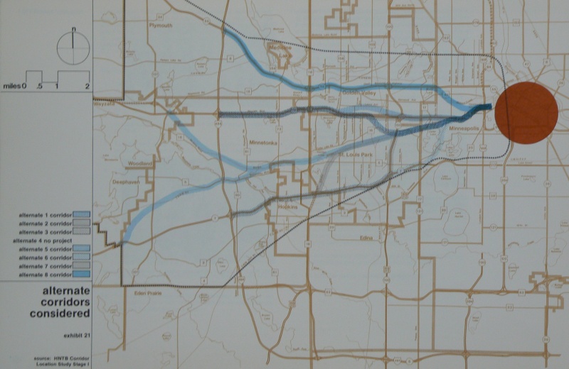
In November, 1970, MHD engaged the consulting firm of Howard, Needles, Tammen and Bergendoff (HNTB) to perform a corridor location study in two stages: Stage I, the identification of feasible corridors, and Stage II, the evaluation of those selected corridors.
There were seven east-west corridors generally following existing transportation corridors between the Hawthorne Interchange in Minneapolis and I-494 in Minnetonka and Plymouth. The corridors were as far south as TH 7 and as far north as TH 55. Once the seven corridors were identified as possible routes for an Interstate facility, each was subjected to a preliminary analysis on the basis of the following criteria:
Two of the alternatives (Alternatives 6 and 7) were eliminated from further detail study. (Webmaster's Note: Alternative 6 followed the alignment of the cancelled Southwest Radial, along the Kenilworth Corridor, to near the Lake St/Minnetonka Blvd intersection, then followed then-MN 7 (now part of CSAH 25 east of MN 100) west to I-494. Alternative 7 followed the BNSF rail corridor westward from near Penn Ave to near Texas Ave, where it followed an old rail spur southwest to near today's US 169/MN 7 junction, then continued west along MN 7 to I-494.)
The Stage II study began in March, 1971, with detailed evaluation of the remaining alternatives. One alternative (Alternative 5) was eliminated from further consideration at a June 1971 Administrative Committee meeting. (Webmaster's Note: Alternative 5 followe the BNSF rail corridor westward from near Penn Ave to a point about halfway between Hopkins Crossroad and Plymouth Rd. Here, Alternative 5 split, with the northern spur continuing along the BNSF corridor to near Crosby Rd then cutting northwest to today's US 12/Gleason Lake Rd interchange. The southern spur, after a short jog to the south, cut westward along Minnetonka Blvd, then followed the old Chicago and Northwestern rail line...now an HCRRA trail...to west of County Road 101, where it turned southwest to meet MN 7 near Vine Hill Rd.)
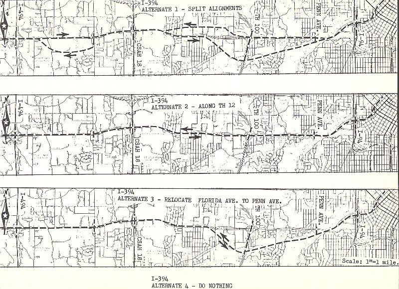
A Limited Improvement Alternative was considered in response to citizen concern about the impact of an Interstate and voiced in the repeated question of "Why not just add a lane on each side of TH 12 and eliminate the signalized intersections?" The Limited Improvement Alternative was not recommended for consideration as a feasible alternative for I-394.
In June, 1971, a Citizens Advisory Committee was established to allow for additional citizen representation in I-394 decisions. The committee was composed of 24 representatives - 12 members and 12 alternate members from the affected municipalities (Minneapolis, Golden Valley, St. Louis Park, Plymouth, Minnetonka, and Wayzata) and the Greater Metropolitan Federations. The committee functioned as a review and advisory body, meeting approximately monthly with representation of MHD, the Metropolitan Council, FHWA, the Metropolitan Transit Commission (MTC), and the consultant.
A technical Advisory Committee consisting of representatives from the planning and engineering staffs of the affected municipalities, MHD, FHWA, Hennepin County, the Metropolitan Council, and MTC reviewed the progress and provided the technical input.
The Administrative Committee, at the recommendation of the Citizens Advisory Committee, was revised in March, 1972 and called the Project Management Board. The board managed the project and made recommendations. Its members included a representative of MHD, the Citizens Advisory Committee, MTC, and the Metropolitan Council.
Through the course of the Stage II effort, an interdisciplinary team of engineers, planners, sociologists, and economists had studied and refined the Alternatives 1, 2, 3, and 4 ("do-nothing option"). On the basis of meeting the established 22 objectives of the study, it was concluded that Alternative 2 (along existing TH 12) best achieved the objectives.
(Webmaster's Note: the text does not say what happened to Alternative 8, but it is obvious that it met the same fate as Alternatives 5, 6, and 7. Alternative 8 would have split just west of I-94 onto the BNSF rail spur that follows Basset's Creek, then turned west to follow MN 55 out to I-494.)
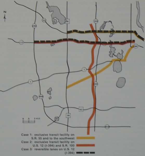
In response to the need for public transit and in order to determine the locations of mainline transit, a supplemental transit study was initiated as part of the project. Three transit cases were analyzed.
The MTC on March 6, 1974 endorsed the redesign of TH 12 to freeway standards but specified that it should not exceed 6 lanes and should only be done in conjunction with the two exclusive transit facilities discussed in Case 1. The Metropolitan Council has supported the preferential treatment of buses and reversible lanes described in Case 3.
The Draft EIS and Section 4(f) Statement was completed and signed on December 28, 1973 by the Highway Commissioner and the Assistant Division Engineer of FHWA and distributed to Federal, state, and local agencies, organizations, and individuals for review and comment.
The Corridor Location Public Hearing was held at the Wayzata High School auditorium on February 27, 1974. The transcript of the hearing, submitted letters and position statements were incorporated into a three volume report.
Since the public hearing, MHD has been collecting additional data for completion of the Final EIS. With the restudy of the corridor as a charge of the Interstate Study Committee, a limited amount of time has been spent on the project since May, 1975.
Segment 2: I-94 to Washington Ave
After receiving Federal authorization in December, 1968 to add this segment to the Interstate system, MHD began developing layouts that would meet the needs of the Third Avenue Distributor. A study called Metro Center 85 prepared by the Minneapolis Planning Commission in March, 1970 considered the proposed location as an important and preferable location for the Central Business District north loop development.
On August 28, 1970, the Minneapolis City Council approved Layout #12 on the proposed project. MHD held a location public hearing on the Third Avenue Distributor on September 14, 1970. In 1971, location approval for the Third Avenue Distributor was requested and received, but subsequently approval was rescinded by the FHWA subject to submittal of an EIS. The Draft EIS was completed in December, 1971 and the Final EIS was completed and accepted by the U.S. Department of Transportation in October, 1973.
Multiple use of the corridor was also considered and a joint domed stadium and parking garage using the aerial rights of the corridor was proposed. The heavily debated stadium proposal was rejected by the city of Minneapolis in February, 1973.
The design public hearing was held on December 12, 1973 in the Minneapolis City Hall chambers. The city then requested the incorporation of three parking garages (for approximately 6,000 vehicles) as a multiple use project in the corridor. The fringe parking garages were a part of the Transportation Control Plan of the Minnesota Pollution Control Agency Air Quality Implementation Plan.
Layout #14 has been developed that incorporates the three parking garages into the project. Data is being collected and funding of the proposed parking garages is being worked on by a task force consisting of members from the city of Minneapolis, MHD, FHWA, and the consultant, Barton-Aschman Associates, Inc.
Design approval is subject to the approvals being received for Segment 1 (I-494 to I-94) of I-394.
Description and Current Status: Segment 1
| Project Limit: | I-494 in Minnetonka to I-94 (Hawthorne Interchange) in Minneapolis |
| Project Length: | 8.5 miles |
| Costs Remaining: | $100 million |
| Costs per Mile: | $11.76 million/mile |
| ROW Acquired: | None |
| Homes Acquired: | None |
| Homes to be Acquired: | Not available |
| Basic Design Proposed by MHD: | Freeway (full access control) |
| Transit Provision: | Preferential bus access ramps with freeway
metering. Other possibilities will be studied during the pre-design phase. |
| Access: | Major interchanges at I-494, CR 18 (today's US
169), TH 100, and I-94. Access interchanges at approximately 1 mile spacing. |
| Traffic Volumes: | (2000 forecasts) 60,000 - 130,000 vehicles per day |
| Estimated Completion of Draft EIS | Completed December, 1973 |
| Estimated Completion Date of Project | 1987 |
Values, amounts, dates, etc. given above may change during the project
development.
Traffic forecasts from Bather, Ringrose and Wolsfeld (BRW) computer output,
medium values.
The location studies, the Draft EIS, and the location public hearing have been held. Additional studies are being worked on to complete the Final EIS so it can be submitted to FHWA to receive location approval. Then the process will continue with citizen involvement to develop alternate design concepts of the proposed roadways, hold the design public hearing and receive design approval. After receiving design approval from FHWA, the detail plans and the start of right-of-way acquisition will begin so that eventually construction could be started in 1981.
Description and Current Status: Segment 2
| Project Limit: | I-94 (Hawthorne Interchange) to Washington Ave in Minneapolis |
| Project Length: | 0.91 mile |
| Costs Remaining: | $10 million (roadway) $30 million (parking garages) |
| Costs per Mile: | $11.0 million/mile |
| ROW Acquired: | 65% |
| Homes Acquired: | Not available |
| Homes to be Acquired: | None |
| Basic Design Proposed by MHD: | Freeway (full access control) |
| Transit Provision: | Preferential bus access ramps with freeway
metering. Other possibilities will be studied during the pre-design phase. |
| Access: | At approxmately 13th Ave, 5th St, 3rd/4th St, Washington Ave, and the three parking garages. |
| Traffic Volumes: | (2000 forecasts) 15,000 - 50,000 vehicles per day |
| Estimated Completion of Draft EIS | Completed December, 1971 |
| Estimated Completion Date of Project | 1981 |
Values, amounts, dates, etc. given above may change during the project
development.
Traffic forecasts from Bather, Ringrose and Wolsfeld (BRW) computer output,
medium values.
The EIS and the Public Hearings have been completed. Data is being collected to complete the Design Study Report so design approval from the FHWA can be received. Right-of-way acquisition could then continue and detailed plans for construction could start in 1979. The current design proposed is a 4-lane divided freeway that is depressed between 13th St N and 3rd St N.
See my I-394 Page
Back to the 1975 Study Report
Back to Froggie's Minnesota Opinion Pages
Back to Twin
Cites Highways
![]()
Page last modified 06 January, 2008