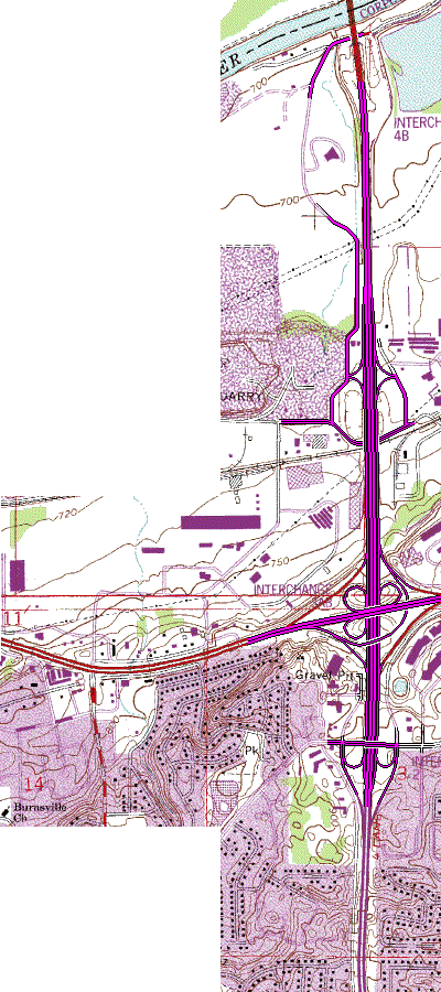
I-35W/MN 13 - Burnsville
My ideas for this area came largely from the now-basically-dead I-35W EIS from a few
years back (dead due to lack of $1 billion to implement it). This area is a
significant bottleneck area for two main reasons. One is the closely-spaced
interchanges along I-35W. Second is the lack of capacity at the Minnesota River
bridge, which is a short ways north of the area. These two combine to form some of
the most severe congestion in Dakota County.
|
This is a fairly long one, so I'm going to break it down into its
individual parts, going north to south. On the north end, the interchange at Black Dog
Road is removed. Two reasons for this. First, the ramps are VERY tight,
causing problems for entering or exiting traffic. Second, not much traffic uses this
interchange anyway, so removal would not cause too many problems. To accomodate
access, a frontage road from Black Dog Road down to Cliff Road will be built and upgraded.
The Cliff Road interchange was a VERY substandard interchange, which required
through-traffic on Cliff Road to make two turns just to stay on the road. This was
partially remedied about 5 years ago on the northbound-side by a realignment of the ramps
and east frontage road. My idea realigns things so that Cliff Road is a continuous
road, with the ramps going to/from the frontage roads. This is also the northern end
of a pair of collector-distributor roads along I-35W, to get the weaving problems caused
by interchange spacing off the mainline.
The I-35W/MN 13 interchange basically stays the same with one exception: a
flyover ramp is built for EB MN 13 to NB I-35W traffic. Today, this loop carries the
heaviest traffic of the 4 loops, and during the morning rush has the heaviest delays due
to the ramp meter. A flyover ramp would improve this situation.
The southernmost interchange is at Burnsville Parkway, currently a folded-diamond to
the south. This interchange would not change very much, except a slight realignment
of the loops to accomodate the south end of the collector-distributor roads.
|
My plan would have 3 lanes each direction along I-35W, with 4 each direction north of
where the C/D roads connect back to the mainline near Cliff Road. The C/D roads
themselves would have 2 lanes each direction between the north end and the MN 13
interchange, as this is where most of the "interchange" traffic would be.
I extended this map west because I'm considering designing an interchange for the
current MN 13/CSAH 5 intersection. The current MN 13 Corridor Study is considering an
interchange at this location as part of a series of measures to improve traffic flow along
MN 13 in this area.
2008 UPDATE: The city of Burnsville and MnDOT have been further
studying this area. A report issued in 2006 offered three options for
improving the I-35W/MN 13 interchange area, to include flyover ramps at the
interchange, C/D roads, replacing the I-35W/Burnsville Pkwy interchange with a
standard diamond, and moving the Cliff Rd interchange to the north to facilitate
redevelopment of the gravel quarry.
In addition, the city and MnDOT have finalized design of an interchange at MN
13/CSAH 5....what I call a partial folded-diamond. The eastbound ramps
will be standard diamond ramps, while the westbound ramps will be folded to the
west, with a westbound off-ramp loop from WB MN 13 to CSAH 5.
Return to Twin Cities Interchange Upgrade Ideas
Return to Froggie's Rantings
Return to Twin Cites Highways

Page last modified
24 May, 2008