Fantasy Duluth, MN transit system
As an add-on to my thoughts on a fantasy transit system for the Twin Cities, below are a few thoughts on a fantasy Duluth system.
The topography of the Duluth area both lends itself very well to a rail transit system, and also lends itself very poorly. On the positive side, the city is very stretched geographically in a southwest-northeast direction, generally following the St Louis River and the shore of Lake Superior. The city also has a few current and former railroad lines aligned in this same direction, lending itself to the possibility of a rail transit system following that direction.
On the flip side, most of the suburban growth of Duluth has been in Hermantown, which sits on top of a long and large ridge that Duluth itself is partially built along. This ridge, though offering some fantastic views of Lake Superior, doesn't lend itself very well to major transportation arteries, and especially rail lines, due to its height and steep slope. As any connection between downtown Duluth and Hermantown would require an east-west or southeast-northwest run almost directly up the ridge, this topographic feature severely limits options even for major highways.
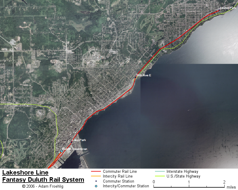
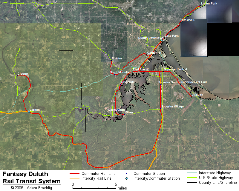
My fantasy Duluth system comprises of five commuter rail lines radiating out from downtown Duluth and utilizing mostly-existing rail track. A map of the lines is below. One line stretches northeast of downtown, with the other four lines heading in a southerly or southwesterly direction. The four lines radiating south/southwest will normally begin at the Downtown Duluth station, located in the old rail depot on Michigan St at 5th Ave W. These lines will have connection to my fantasy Twin Cities-to-Duluth intercity line at the downtown station. Besides the downtown station, these four south/southwest lines will have an alternate option for a downtown station at Lake Park (on the other side of I-35 from downtown). Due to the lack of trackage northeast of the old downtown rail station, the northeastern line does not have this option and instead stops near Lake Park.
The lines (click on a line name for a more detailed map of that line):
Lakeshore: this three-station line is the one that runs northeast of downtown, using the St Louis & Lake County rail tracks that parallel I-35, London Rd, and the lakeshore. Instead of a downtown Duluth station at the old rail depot, this line's "downtown" station is at Lake Park, located between I-35 and Railroad St just north of Harbor Dr. The other two stations are 26th Ave E, located along London Rd just north of where it crosses the tracks near 26th Ave E/I-35, and Lester Park, located where the tracks cross 60th Ave E.
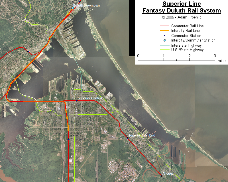
Superior: this line provides a non-stop connection between downtown Duluth and downtown Superior, and extends into southeastern Superior. From the Downtown Station, this line runs southwest along Burlington Northern Santa Fe (BNSF) trackage, turns east and crosses the St Louis River on the railroad bridge south of US 2, and continues east onto Union Pacific trackage to the Superior Central station, located along N 9th St between John Ave and Ogden Ave. The line continues east then southeast along the Union Pacific trackage, with two more stops, at Superior Southeast (on 18th Ave E) and at Allouez (on 39th Ave E).
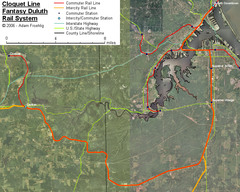
Cloquet: this line provides a roundabout connection between downtown Duluth and Cloquet, utilizing BNSF trackage the entire way. This line starts heading southwest from downtown and crossing the St Louis River as does the Superior line. East of the river, this line turns southward paralleling WI 35 for several miles. There are two stations along this stretch: Superior South (at N 28th St) and Superior Village (at WI 105/N 61st St). South of Superior Village, this line takes the BNSF route west into Minnesota, with a station in Carlton (off North Ave) and the last station in Cloquet (on Avenue B near 8th St).
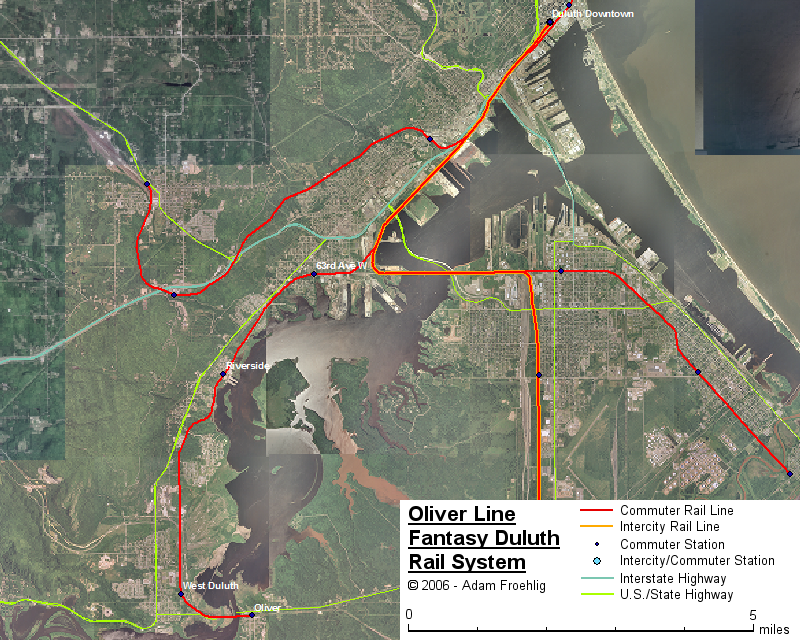
Oliver: this line stretches southward through "western" Duluth and across the river into Oliver, WI. As with the Superior and Cloquet lines, it heads southwest from downtown on BNSF trackage. Then at the point where the BNSF tracks turn east to cross the river, the Oliver line continues southwest along a Duluth Missabe & Iron Range (DMIR) line. This line continues southward through west Duluth, then crosses the St Louis River on a combination road/rail bridge into Oliver, WI. This line has four stations: 63rd Ave W (near Redruth St, south of Grand Ave/MN 23), Riverside (on Spring St near the marina), West Duluth (at the end of 95th Ave W north of Peary St), and Oliver (east side of CTH "W").
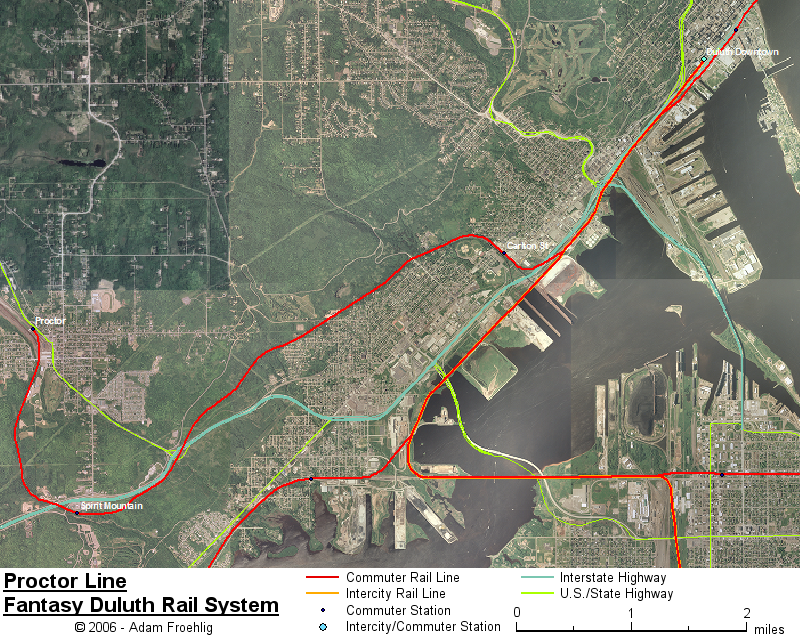
Proctor: the last of the four lines heading southwest from downtown, this is one of only two lines that climbs the ridge heading up away from the lake/river (the Cloquet line being the other). This line also heads southwest from downtown on BNSF trackage, to a point southwest of 27th Ave W where it splits off onto DMIR trackage for a long climb up the ridge. Partway up the ridge is the Carlton St station, on Carlton St just east of Grand Ave. Near the top of the ridge after a long climb is the Spirit Mountain station, located behind the commercial development on Skyline Pkwy at the I-35/Boundary Ave interchange. The last station is the Proctor station on US 2 at 6th St in Proctor.
Back to Twin Cities fantasy transit system
Go to my suggested
freeway/expressway changes.
Go to my ideas for improving/upgrading Twin Cities area
interchanges.
Return to Twin Cites Highways
![]()
Page last modified 27 May, 2007