Inver Grove Line (fantasy transit)
The idea of a modern transit line running south from downtown St. Paul to Inver Grove Heights began with the ca. 1990 studies for a regional LRT system, further culminating in a 1991 Scoping Document for the St. Paul South LRT line that recommended a Lafayette Freeway alignment. In 2007, Dakota County began a new transit study on the Robert St/Lafayette Freeway corridor to determine the best transit mode for the corridor. My fantasy transit line is based in part on Alternative 4 from the current 2007-08 study, generally using the Robert St corridor south to I-494, then the US 52 corridor down to Inver Hills Community College.
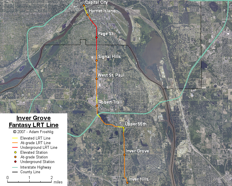
Starting south of the Mississippi River on the east side of Wabasha St, the line follows the east side of Wabasha, then goes into tunnel just south of Plato Blvd. The line stays underground on its way up the river bluff, eventually returning to grade in the Robert St median near Bernard St (2 blocks south of Annapolis St). The line follows the Robert St median, bridging over Mendota Rd. South of Mendota Rd, the line shifts to the east side of Robert St, passes under MN 110, then crosses over I-494 following the southwest shore of Schmitt Lake. The line then follows Upper 55th St eastward, bridging over US 52 and the Upper 55th/Blaine Ave intersection, then turns south and follows Blaine Ave to its end at Inver Hills Community College.
Stations would be provided at the following:
The following map shows the routing of my fantasy Inver Grove LRT line:
Back to my fantasy Twin Cities Light Rail Transit
Back to Twin Cities fantasy transit system
Go to my suggested
freeway/expressway changes.
Go to my ideas for improving/upgrading Twin Cities area
interchanges.
Return to Twin Cites Highways
![]()
Page last modified 23 December, 2007