
Southwest Line (fantasy transit)
This fantasy line is largely based on ongoing Hennepin County studies on rail transit in the Southwest Corridor. I've used Alternate 3A (recommended as the preferred alternative in the real life study) as my baseline, with some modifications and a considerable extension included.
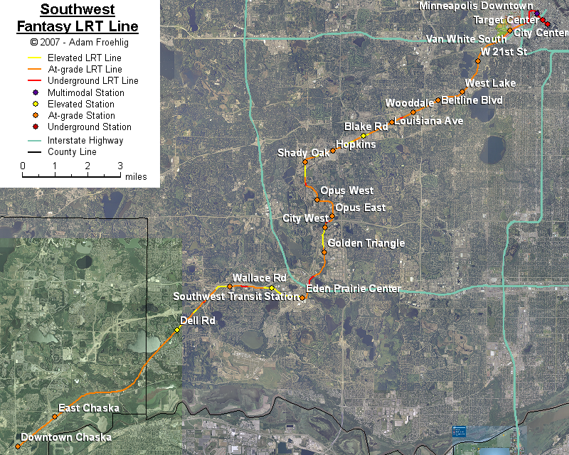
Starting at the downtown Multimodal station, the line continues underground (as the downtown line is in a tunnel at the station), making a loop around the north side of the Hennepin County incinerator, then heads south underneath Royalston Ave. The line follows Royalston Ave south for a few blocks, then turns southwest along the southside of the BNSF tracks, returning to grade near the I-94 overpass. The line continues southwestward, following the southeast side of the BNSF and then TCW tracks underneath 394 and then southwest along the Kenilworth Trail. The line would be bridged over Cedar Lake Pkwy. About halfway between Louisiana Ave and Wooddale Ave, the line briefly tunnels underneath a relocation of the TCW tracks onto a CP rail line. The line follows the north side of the TWC tracks west of this point to just west of US 169, elevating over both Blake Rd and Excelsior Blvd in the process. West of US 169, the Southwest Line follows the HCRRA bike trail that is south of Excelsior Blvd, crosses over 11th Ave, and continues westward to near 16th Ave at the Hopkins/Minnetonka line. Here the line turns due south along the Hopkins/Minnetonka line to near Smetana Rd, passing over the TCW tracks and underneath Smetana Rd in the process.
South of Smetana Rd, the line passes through the Opus and Bren Rd office park areas, generally following a Feltl Rd/Bren Rd W/Bren Rd E/Blue Circle Dr routing, ending near the west side of Crow Lake. The line then briefly turns westward, crossing over MN 62 into the City West area of Eden Prairie. It briefly follows the west side of US 212 before crossing over US 212 just north of the Shady Oak Rd ramps, then bridges over the Shady Oak Rd/Flying Cloud Dr intersection. The line then heads southward to a location within the Golden Triangle near 70th St W. South of Golden Triangle, the line briefly turns southwest, crossing Nine Mile Creek and Flying Cloud Dr, then follows the east side of the US 212 right-of-way down to Valley View Rd.
The line begins a long elevated section north of the Flying Cloud Dr/Valley View Rd intersection, passing over Valley View Rd, Viking Dr, Flying Cloud Dr, and I-494 before coming back to grade on the north side of Technology Dr across from Lake Idlewind. The line then crosses at-grade to the south side of Technology Dr and follows that route down to the Southwest Transit Station, briefly tunneling under Prairie Center Dr in the process.
West of Southwest Transit Station, the line follows the south side of MN 5, tunneling under Mitchell Rd then bridging over both Wallace Rd and MN 312/Future US 212 enroute to the SW Hennepin trail. The line follows the SW Hennepin trail all the way into Chaska before ending in downtown Chaska, with grade separations along the trail at CSAH 4, Future US 212, Dell Rd, Pioneer Tr, Great Plains Blvd, and existing US 212 on the Chaska/Chanhassan line.
Stations would be provided at the following:
In a pinch, the line could be cut short and end at the Southwest Transit Station, with the extension to Chaska occurring when population density or travel demand support it.
The following map shows the routing of my fantasy Southwest LRT line:
An earlier version of this map, using my original alignment around Eden Prairie Center, is here.
Back to my fantasy Twin Cities Light Rail Transit
Back to Twin Cities fantasy transit system
Go to my suggested
freeway/expressway changes.
Go to my ideas for improving/upgrading Twin Cities area
interchanges.
Return to Twin Cites Highways
![]()
Page last modified 24 October, 2009