
Former California State Highway 209
According to Dan Faigin of cahighways.org, CA 209 no longer exists. It previously ran from the I-5/I-8 interchange southwestward along Rosecrans St, then westward up a hill along Canon St, then southward along Catalina Blvd and through a U.S. military reservation, ending at Cabrillo National Monument on Point Loma. Though CA 209 no longer officially exists, several route markers remain, both on I-8 and along the route itself. All photos were taken by the webmaster in October, 2007.
|
|
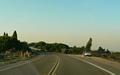
Northbound "CA 209" coming out of Cabrillo National Monument. |
|
|
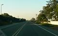
Three photos showing former CA 209 (including one with a route marker still existing) through the military reservation, between Cabrillo National Monument and Catalina Blvd. |
|
|
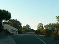
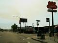
Now along northbound Rosecrans St, this is the intersection with Hugo St. One block east (to the right) along Hugo St is the start of Harbor Drive. |
|
|
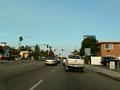
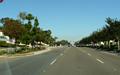
Along northbound Rosecrans St, somewhere north of Nimitz Blvd. The area to the right used to be a U.S. Navy Recruit Training Center. The center closed in the 1990s, and has since been extensively redeveloped with both housing and retail. |
|
|
Southbound Rosecrans St at Oliphant St (a few blocks north of Nimitz Blvd), showing a white-background "END BIKE LANE" sign. |
|
|
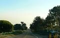
Southbound on the military reservation, with a military cemetery on the left. |
|
|
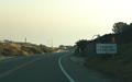
The south end of former CA 209 is at the entrance to Cabrillo National Monument. |
Back to Froggie's San
Diego area highway photos
See some of Froggie's non-road-related
San Diego photos
Back to Highway
Photography
Dan Faigin's page on
Former CA 209
![]()
Page last modified 12 November, 2007
(C) 2007 Adam Froehlig